Proximal sensing across research fields: one term, many traditions
Proximal sensing is used in many fields, but it does not always mean quite the same thing.
In soil science, it may include a sensor inserted into the ground or a ground-penetrating radar. In vegetation science, it may mean a spectrometer held above a leaf or a camera mounted on a tower. In crop research, it may refer to a sensor mounted on a tractor or drone. In inland-water monitoring, it may describe a hyperspectral camera observing a lake from the shore or a radiometer mounted on a moored buoy. In snow and ice research, it may involve a field instrument, a terrestrial scanner, or a drone observing a glacier surface.
The shared idea is simple: the sensor is close enough to the target to make detailed and relatively controllable observations. But what counts as close, what counts as the target, and what the measurement is intended to represent all vary between disciplines.
This diversity of definitions is an opportunity to understand what these fields have in common, where their approaches differ, and what they can learn from one another.
Soil: close to, or inside, the target
Proximal sensing has perhaps its most traditional and most established identity in soil science.
Here, the target is often physically complex and highly variable over short distances. Soil texture, moisture, organic matter, salinity, compaction, mineral composition, and carbon content can change substantially over a few metres, or even across a single field. Conventional soil sampling remains essential, but collecting enough samples to represent this variability is slow and expensive.
Proximal soil sensing developed in response to this challenge. It commonly includes sensors that are in contact with the soil, inserted into it, or operated very close to the surface. Examples include electromagnetic induction, ground-penetrating radar, gamma-ray sensors, electrical conductivity sensors, visible and near-infrared spectrometers, and soil-moisture probes.
This tradition is notable because it treats proximity broadly. The sensor may be stationary at one point, mounted on a vehicle, pulled across a field, or used to scan a soil core. It may measure a soil property directly, or it may measure a signal that is related to that property through calibration and modelling.
For soil scientists, the practical value of proximal sensing often lies in mapping. The goal is not only to know the soil at one location, but to understand how it varies across a field or landscape. This makes proximal sensing central to digital soil mapping, precision agriculture, carbon monitoring, contaminated-site assessment, and studies of soil-plant interactions.
The soil science proximal sensing tradition also offers an important lesson for other fields: a proximal sensor does not need to be non-contact. In some cases, contact with the target is not a limitation. It is the reason the measurement is possible.
Vegetation: from leaves to canopies
In vegetation research, proximal sensing often focuses on the condition, structure, function, and change of plants.
At leaf scale, this may involve chlorophyll meters, fluorometers, leaf chambers, handheld spectrometers, thermal cameras, or instruments that measure gas exchange. At canopy scale, it may involve fixed cameras, multispectral sensors, terrestrial laser scanners, phenotyping systems, tower-based radiometers, or drone-mounted cameras.
The target can be a single leaf, an individual plant, a crop row, a forest canopy, or an entire ecosystem. That range of targets makes vegetation sensing both powerful and methodologically challenging.
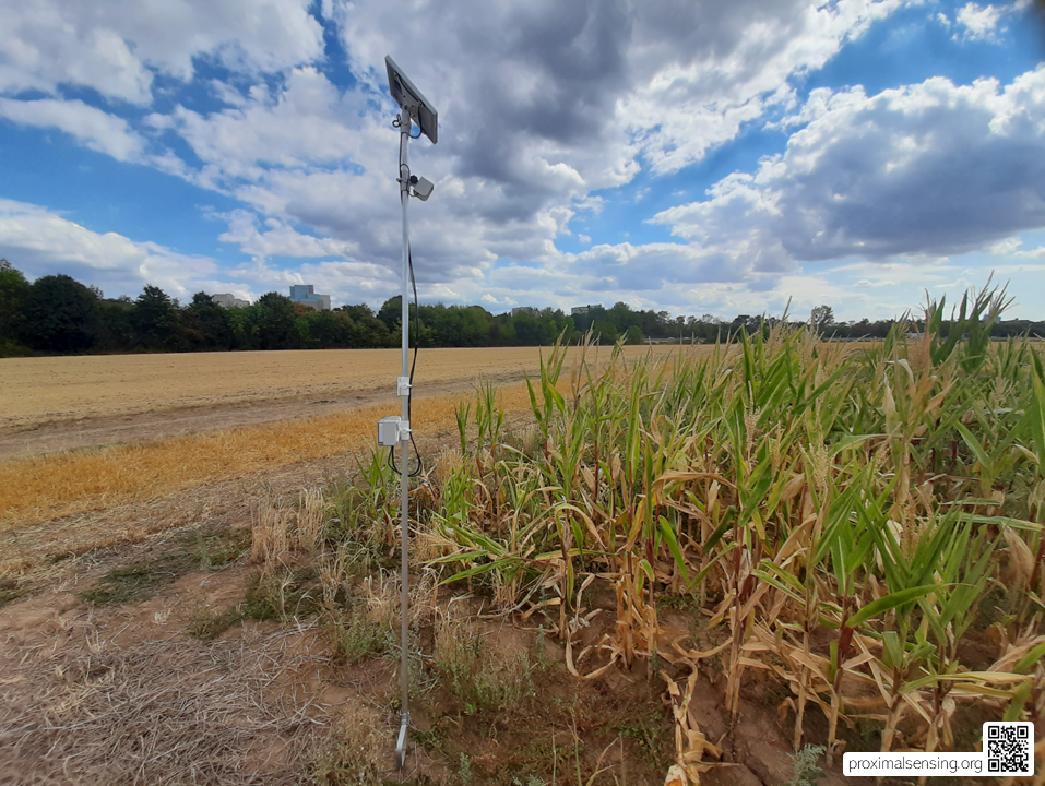
Figure 1. Agricultural field camera used for proximal sensing and continuous crop monitoring.
A measurement made on one leaf may be precise, but it may not represent the whole plant. A camera looking at a canopy may capture more of the vegetation, but its signal can be influenced by shadows, soil background, leaf angle, illumination, viewing direction, and changes in canopy structure. The question of scale is therefore always present.
In precision agriculture, proximal crop sensing is frequently connected to management decisions. Tractor-mounted optical sensors can estimate crop condition while moving through a field, sometimes supporting variable-rate fertiliser applications. Handheld or drone-based systems can identify spatial variation in crop development, nutrient status, water stress, disease symptoms, or weed pressure.
In ecosystem and phenology research, fixed cameras and spectral sensors make repeated observations from stable positions. The typical system used here are the PhenoCams. These systems can reveal seasonal development, canopy greenness, flowering, senescence, stress responses, and short-term dynamics that may be missed by occasional field campaigns or cloud-affected satellite observations.
This vegetation tradition has given rise to the term proximal remote sensing. The phrase may sound contradictory at first, but it is useful. It acknowledges that a camera or spectrometer can observe a target without touching it, while still operating from a short enough distance to provide detailed, frequent, and often well-controlled measurements.
Inland water: observing a dynamic surface
Inland-water monitoring presents a different set of challenges.
Water bodies change rapidly. Wind, waves, suspended sediment, algae, dissolved material, surface reflections, clouds, and changing illumination can all influence what a sensor observes. Water quality can change within hours, particularly during runoff events, algal blooms, or pollution incidents.
Traditional water sampling provides important chemical and biological information, but it is often spatially sparse and infrequent. Satellite observations can provide broad coverage, but inland waters are difficult targets because many lakes and rivers are relatively small, spectrally complex, and sensitive to atmospheric and adjacency effects.
This is where proximal sensing can be especially valuable. A spectrometer, radiometer, or hyperspectral camera mounted close to the water surface can observe a lake, river, or reservoir repeatedly and at fine spatial detail. Such systems can be installed on shore, on a bridge, on a tower, a moored buoy or on a boat. They can complement water samples and in situ probes by providing a continuous optical record of surface conditions.
In this context, proximity is not only about reducing the atmospheric path. It is also about capturing rapid change. A proximal observation system can measure the same part of a water body every few minutes, while a satellite may pass only occasionally and may be obscured by cloud.
The challenge is that water is not a stable target. The geometry between sensor and surface, sun angle, wind conditions, reflections from the sky, and the viewing direction all matter. Water monitoring therefore makes a strong case for treating sensor-target geometry as part of the measurement itself, rather than as a technical detail to be dealt with later.
Snow and ice: proximity in difficult environments
Snow and cryosphere research use a wide range of field, airborne, and satellite observations. Proximal sensing is particularly valuable where the properties of snow and ice vary at scales that are difficult to capture from space.
Snow depth, grain size, liquid-water content, density, surface roughness, albedo, impurities, and melt state can all change over short time periods. A single snow pit may provide detailed information at one location, but it cannot represent an entire slope, glacier, or catchment. Satellite products provide large-scale coverage, but often cannot resolve the local conditions that control melt, runoff, avalanche risk, or ecological processes.
Close-range cameras, drones, terrestrial laser scanners, spectrometers, ground-based radar, and automated stations can help bridge this gap. They can document snow accumulation and melt, map surface structure, monitor changes in glacier margins, and observe the timing and distribution of seasonal transitions.
Cryosphere research also highlights that proximity does not always mean convenience. Sensors may be close to the target, but field conditions can be severe. Instruments must cope with cold, moisture, snow burial, difficult access, unstable surfaces, and rapidly changing light conditions.
This is a useful reminder that proximal sensing is not defined simply by technical capability. It is shaped by the practical realities of placing, maintaining, calibrating, and interpreting sensors in the field.
Urban environments: sensing the local city
In urban research, the term proximal sensing is used less consistently than in soil or crop science. Yet many urban measurement systems clearly share its characteristics.
Cities are highly heterogeneous environments. Temperature, air quality, noise, traffic, vegetation condition, surface materials, energy use, and water dynamics can vary from one street to the next. Satellite observations provide an essential overview, but they often cannot resolve the microclimates and local processes experienced by people at street level.
Proximal approaches include field cameras, thermal sensors, mobile mapping systems, low-cost environmental sensor networks, street-level spectrometers, terrestrial laser scanning, and sensors mounted on vehicles, bicycles, buildings, or public infrastructure.
These systems can reveal local variation in urban heat, air pollution, shading, vegetation, surface temperature, and building form. They can also support more responsive monitoring by measuring conditions where people live, travel, and work.
Urban sensing introduces an additional set of concerns: privacy, access, infrastructure, data ownership, and the social consequences of measurement. A camera in a remote field and a camera on a city street may use similar technical principles, but they operate within very different ethical and institutional settings.
That difference matters. Proximal sensing is not only a set of instruments and methods. It is also shaped by where, why, and for whom observations are made.
What the fields share
Across these domains, the instruments differ, but several questions return again and again.
What exactly is the target?
At what scale is the target being observed?
How representative is the observation?
How stable is the measurement geometry?
Which environmental conditions influence the signal?
How is the sensor calibrated and validated?
And how can a signal be translated into information that is useful beyond the immediate measurement?
These are not questions belonging exclusively to soil science, vegetation monitoring, hydrology, cryosphere research, or urban sensing. They are proximal sensing questions.
The value of bringing these fields together is not that they should all use identical methods or language. Their targets, measurement physics, and applications are genuinely different. The value lies in recognising shared methodological problems.
A soil scientist mapping salinity across a field, an ecologist operating a phenology repeat camera, a hydrologist monitoring lake reflectance, a glaciologist scanning snow surfaces, and an urban researcher measuring street-level temperature may all be wrestling with variations of the same problem: how to make high-resolution observations near the target that are interpretable, repeatable, and meaningful at a larger scale.
A field built through exchange
Proximal sensing may be most useful not as a tightly bounded discipline, but as a meeting place.
It provides a language for discussing measurements that are too close, too detailed, too frequent, or too controlled to fit comfortably within conventional remote sensing alone. At the same time, it connects these observations to questions of scaling, calibration, modelling, and monitoring that extend well beyond the immediate field site.
Each discipline has developed valuable knowledge that others can use. The field does not need to become uniform to become coherent. It needs more exchange between the people who build sensors, collect data, develop methods, and interpret observations close to the things they want to understand. That is where proximal sensing has the potential to become more than a label. It can become a shared methodological space.
Explore further:
- Viscarra Rossel, R. A., Adamchuk, V. I., Sudduth, K. A., McKenzie, N. J., and Lobsey, C. (2011). Proximal soil sensing: An effective approach for soil measurements in space and time. Advances in Agronomy, 113, 237–283. https://doi.org/10.1016/B978-0-12-386473-4.00005-1
- Tao, H., Xu, S., Tian, Y., Li, Z., Ge, Y., Zhang, J., Wang, Y., Zhou, G., Deng, X., Zhang, Z., Ding, Y., Jiang, D., Guo, Q., and Jin, S. (2022). Proximal and remote sensing in plant phenomics: 20 years of progress, challenges, and perspectives. Plant Communications, 3(6), 100344. https://doi.org/10.1016/j.xplc.2022.100344
- Pierrat, Z. A., Magney, T. S., Richardson, A. D., Runkle, B. R. K., Diehl, J., Yang, X., et al. (2025). Proximal remote sensing: An essential tool for bridging the gap between high-resolution ecosystem monitoring and global ecology. New Phytologist, 246(2), 419–436. https://doi.org/10.1111/nph.20405
- Xiao Sun, Yunlin Zhang, Kun Shi, Yibo Zhang, Na Li, Weijia Wang, Xin Huang, Boqiang Qin, (2022), Monitoring water quality using proximal remote sensing technology, Science of The Total Environment, 803, 149805. https://doi.org/10.1016/j.scitotenv.2021.149805
Leave a Reply