Some measurements are made during a field campaign. Others are made every day.
A field visit may produce detailed measurements of plants, soil, water, snow, or surface conditions. A drone flight can capture a highly detailed snapshot of a field on a particular morning. A satellite can provide repeated observations across a region or even a continent.
But many environmental processes do not follow our measurement schedules.
Crops emerge and develop between field visits. Canopies respond to heat, drought, and rainfall over hours or days. Rivers change after a storm. Snow accumulates overnight and melts unevenly across a landscape. Urban trees respond to heat and water stress in places where satellite pixels cannot distinguish one street from the next.
A field camera offers a deceptively simple response to this problem. Place a camera in a stable position, point it towards a target, and let it keep observing.
When maintained over time, that camera becomes more than an imaging device. It becomes a persistent observer.
A camera that stays
Field cameras are often fixed cameras installed outdoors to capture repeated images of the same target or scene. These can be as simple as trail cameras set to a repeat mode to take pictures every 30 min to very advanced connected camera systems that have edge-computing options for change detection. They may be mounted on towers, poles, buildings, tripods, weather stations, agricultural infrastructure, or purpose-built enclosures.
The basic idea is straightforward. A camera observes the same scene at regular intervals, often every few minutes or every hour. Over days, seasons, and years, this produces a visual record of environmental change.
This continuity is one of the main strengths of field cameras.
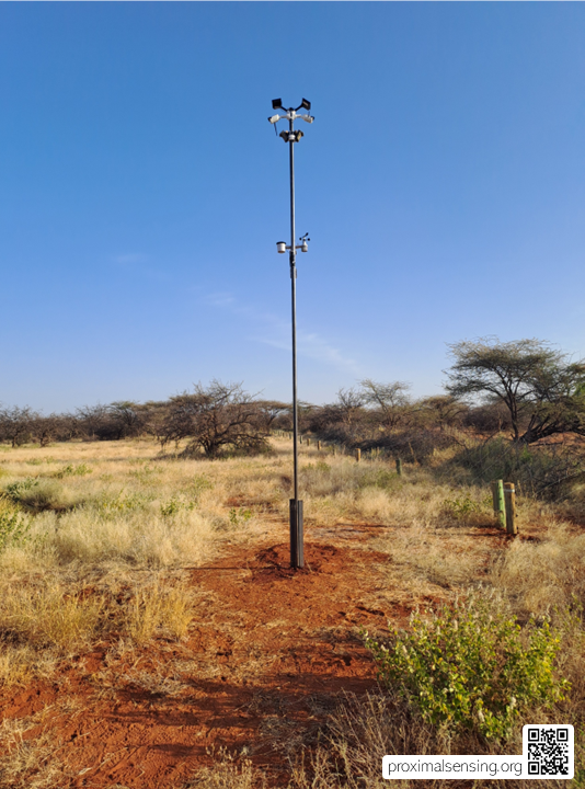
Figure 1. Field cameras can range from simple trail cameras programmed for repeated image capture to connected RGB and thermal camera systems with edge processing and long-range communication. Here, a camera system installed alongside a weather station monitors grass conditions in the ASAL regions of Kenya, linking repeated imagery with local environmental observations.
Many field measurements are necessarily episodic. A researcher visits a site, collects samples, measures vegetation, flies a drone, or deploys an instrument for a limited period. These observations can be extremely valuable, but they capture only a small part of the temporal dynamics of a system that can be seen as a snapshot.
A fixed camera records what happens between those moments.
It can show when a crop emerged, when a canopy closed, when flowering began, when standing water appeared after rainfall, or when snow cover disappeared from a slope. It can provide context for a surprising sensor reading, reveal a management event that was not recorded elsewhere, and help distinguish a genuine environmental signal from an instrument problem.
The camera does not replace field measurements. It gives them a timeline.
From PhenoCams to field cameras
The best-known example of this approach is the PhenoCam network.
PhenoCams are digital RGB cameras that repeatedly observe vegetation, often from above or beside a canopy. Their images are used to track visible seasonal change, including spring green-up, canopy development, autumn senescence, and the duration of the growing season.
A typical PhenoCam is mounted in a stable position and looks towards a defined region of interest. The camera captures images throughout the day. From these images, researchers can derive time series of canopy colour and greenness, including indices based on the relative intensity of red, green, and blue image channels.
The scientific value is not simply that the camera produces attractive seasonal photographs. It comes from repetition, stable geometry, processing protocols, and long-term data management.
The PhenoCam network showed how relatively simple cameras could become part of a continental scientific observatory. By combining common acquisition practices, repeated images, defined regions of interest, quality control, and shared data products, individual camera installations became comparable across sites and ecosystems.
But the underlying idea extends well beyond vegetation phenology.
A field camera can be understood more broadly as a proximal sensing system that repeatedly observes a target from a relatively stable and controllable viewpoint.
More than vegetation
Vegetation monitoring is a natural application for field cameras, but it is far from the only one.
In agriculture, cameras can observe crop emergence, canopy development, flowering, senescence, lodging, irrigation events, residue cover, field access, and visible signs of disturbance. They can provide a continuous visual record that supports crop scouting, drone campaigns, field experiments, and the interpretation of weather or soil sensor data.
In forest and ecosystem research, tower-mounted cameras can document canopy development, leaf colour, disturbance, snow cover, understory visibility, and changes in vegetation structure. They can help connect observations of individual leaves and plants with measurements made at tower, ecosystem, and satellite scales.
In soil research, cameras can record surface wetness, crusting, cracking, erosion, residue cover, tillage, and changes in the appearance of bare soil. A camera cannot directly measure every soil property, but it can provide important context for interpreting observations made by probes, spectrometers, weather stations, or repeated sampling.
In inland water monitoring, a field camera can observe changes in water level, surface condition, floating vegetation, ice, sediment plumes, or local disturbances. Combined with water quality probes and close-range spectral measurements, repeated imagery can help reveal how an event develops through time.
In snow and cryosphere research, cameras can record snow accumulation, melt, surface change, glacier margins, and the timing of seasonal transitions. They are particularly useful when satellite observations are limited by cloud cover or when field access is difficult.
Urban environments provide another interesting application. Field cameras can support observations of vegetation, shading, surface wetness, flooding, construction, heat-related conditions, and local land-use change. In these settings, camera placement and data management also need to account for privacy and the social context of observation.
The target changes from field to field. The principle does not.
A camera that observes a target repeatedly, from a known position and with a documented workflow, can create a valuable proximal record of environmental change.
The value of a fixed viewpoint
The fixed viewpoint is often treated as a practical convenience. In fact, it is a scientific advantage.
When a camera remains in the same position and observes the same part of a scene, changes in the image are more likely to reflect changes in the target rather than changes in where or how it was observed.
This does not eliminate uncertainty. Lighting changes throughout the day. Clouds alter the quality and direction of illumination. Shadows move. Rain, fog, snow, dust, condensation, insects, and vegetation growth can obscure the lens or change the scene. The camera itself may shift after strong wind, maintenance, or accidental contact.
But stable geometry removes one important source of variation.
This matters because environmental signals are often subtle. A small shift in camera orientation can look like a change in canopy cover. A different exposure setting can affect colour-based indices. A region of interest that includes more sky, soil, or shadow than intended can change the apparent signal even when the vegetation itself has not changed.
A field camera therefore works best when its geometry is treated as part of the measurement system.
The camera position, orientation, height, field of view, acquisition frequency, and definition of the target all become part of the observation.
These details may seem technical, but they determine whether a collection of photographs can become a reliable time series.
Across scales
Field cameras are especially useful because they occupy an important position between close-up measurements and broad-scale observation.
A leaf-level instrument may measure chlorophyll, fluorescence, temperature, or gas exchange with great detail. A soil probe may measure moisture at a particular depth and location. A drone can map a field at centimetre-scale resolution. A satellite can observe large areas repeatedly over long periods.
Each provides a different view of the world.
A field camera often sits between these scales. It can observe plants, plots, crop rows, sections of canopy, riverbanks, snow slopes, or urban street scenes. It provides far more spatial detail than a satellite image and far more temporal continuity than occasional drone flights or field visits.
This makes it a useful bridge.
Leaf and plant -> Canopy and plot -> Field and ecosystem -> Landscape -> Airborne and satellite observation
A camera can help establish whether observations at these different scales describe the same process.
For example, a field campaign may show that leaf temperature increased during a dry period. A tower camera can show whether the wider canopy changed at the same time. A drone flight can map whether the response varied across the field. Satellite observations can then place the event within a broader regional pattern.
The camera does not solve the problem of scaling on its own. What it provides is continuity and context between observations that would otherwise remain disconnected.
From image to data
The most important shift is to stop thinking of a field camera as a source of photographs. A field camera is a source of data.
The images are the raw observations, but their scientific value depends on what happens before and after image acquisition.
Before deployment, the target, viewing geometry, camera settings, power supply, mounting system, network connection, and capture schedule all need to be considered. During operation, the system needs monitoring. Are images still arriving? Has the camera moved? Is the lens clean? Has vegetation grown into the field of view? Is the clock correct? Has the system switched to a different exposure mode?
After acquisition, images need storage, documentation, quality control, and processing.
A useful field-camera workflow therefore includes original images with stable timestamps and identifiers, camera and site metadata, documented camera position and orientation, defined regions of interest, quality-control flags, derived data products, versioned processing code, and links to co-located weather, soil, plant, flux, drone, or satellite observations.
This is what allows images to become comparable through time.
It also allows another researcher to understand what was measured, how it was processed, and what limitations should be considered.
From camera to network
One well-maintained camera can be scientifically useful. A network of cameras can become much more powerful.
A network does not need to begin with hundreds of installations across a continent. It can start with a small number of sites using compatible approaches. The important part is that the observations can eventually be understood, compared, and combined.
For this, a network needs more than connected devices. It needs shared practice.
Sites and cameras need persistent identifiers. Cameras need documented metadata. Images need consistent timestamps. Processing needs transparent methods. Data quality needs to be described, not assumed. Access rules need to be clear. Whenever possible, observations should be connected to other measurements made at the same site.
This is where field cameras meet the broader world of environmental IoT.
Connectivity allows images and system-status information to be transmitted from the field. Automated workflows can check whether data are arriving, whether a camera has shifted, or whether a lens may be obstructed. Shared infrastructure can archive images, produce standard data products, and make selected observations discoverable to others.
But networking is not simply a technical problem.
A collection of cameras connected to the internet is not yet a scientific camera network.
A scientific network emerges when sensors, metadata, quality control, processing, interpretation, and access are designed to work together.
A camera is a measurement system
The simplicity of field cameras can be misleading.
A camera appears to offer a direct view of the world. In reality, every image is shaped by the camera, lens, exposure settings, illumination, viewing angle, atmosphere, target structure, and processing decisions.
This does not make cameras unreliable. It makes them instruments.
The appropriate response is not to treat images as either objective truth or merely illustrative material. It is to describe the observation system carefully, evaluate uncertainty, and design workflows that make the data useful.
For many applications, relative change through time may be more robust than an absolute estimate of a physical property. A camera may be excellent at showing when a canopy becomes greener, when snow disappears, or when a water surface changes appearance, even if converting those changes into chlorophyll concentration, biomass, or soil moisture requires additional calibration.
The relationship between image signal and environmental process needs to be tested rather than assumed.
This is one reason field cameras are especially valuable when combined with other observations. A camera can provide temporal context. A spectrometer can provide detailed spectral information. A soil or weather sensor can provide environmental conditions. Field samples can establish reference measurements. Drones and satellites can extend observations across space.
Together, these systems provide more than any single instrument could provide alone.
The next observatories may be small
The future of field cameras does not depend only on larger networks, more cameras, or more images. It depends on better observation systems.
That may mean small networks of carefully installed cameras in agricultural fields, forest stands, water catchments, snow environments, or urban neighbourhoods. It may mean camera systems designed from the beginning to work alongside weather stations, soil sensors, drones, and satellite data. It may mean open tools that allow researchers to share not only images, but also metadata, processing methods, and lessons learned.
The most useful camera network may not be the one with the most devices. It may be the one that makes its observations understandable across time, across sites, and across scales.
Field cameras remind us that proximal sensing is not only about getting closer to a target. It is also about staying with it.
Explore further
- Pierrat, Z. A., Magney, T. S., Richardson, A. D., Runkle, B. R. K., Diehl, J., Yang, X., et al. (2025). Proximal remote sensing: An essential tool for bridging the gap between high-resolution ecosystem monitoring and global ecology. New Phytologist, 246(2), 419–436. https://doi.org/10.1111/nph.20405
- Richardson, A. D., Hufkens, K., Milliman, T., Aubrecht, D. M., Furze, M. E., Seyednasrollah, B., et al. (2018). Tracking vegetation phenology across diverse North American biomes using PhenoCam imagery. Scientific Data, 5, 180028. https://doi.org/10.1038/sdata.2018.28
- Sonnentag, O., Hufkens, K., Teshera-Sterne, C., Young, A. M., Friedl, M., Braswell, B. H., et al. (2012). Digital repeat photography for phenological research in forest ecosystems. Agricultural and Forest Meteorology, 152, 159–177. https://doi.org/10.1016/j.agrformet.2011.09.009
Leave a Reply