I have always been fascinated by stop-motion videos of individual plants growing. A picture is taken every day at the same time, and the images are later assembled into a video showing the different stages of plant development. This can look like a niche scientific application, for example when studying the influence of light on crop development. But the uses of repeat photography in agriculture, ecology, and environmental monitoring are almost endless.
When a camera is placed outdoors and pointed towards a landscape, it can record change over days, seasons, and years. A landscape may become greener after winter as new plants emerge and leaves appear on trees. It may dry out and become more yellow during a summer drought. A camera can document agricultural management from ploughing to harvest, monitor the greenness of fodder resources across a landscape, or record the changing condition of a river, wetland, shoreline, or snow-covered slope.
Repeat photography is now used across scientific disciplines far beyond vegetation monitoring.
For many applications, relatively simple, off-the-shelf digital RGB cameras are sufficient. These are ordinary devices, but they can become useful scientific instruments when they are used consistently and interpreted carefully. An RGB camera records visible light through red, green, and blue channels. It can be placed in a weatherproof enclosure, mounted on a pole or tower, powered by a battery or solar panel, and programmed to take an image at regular intervals. At its simplest, it may be a trail camera recording a scene every 30 minutes.
This apparent simplicity is part of its scientific value. Environmental change is often gradual, uneven, and easily missed. A field visit may record the state of a crop, canopy, grassland, water body, or snow surface on a particular day. It provides a valuable snapshot. A drone flight may provide a detailed image of a field at a particular moment. A satellite can extend observation across large areas. But many processes develop between these measurements. A field camera remains in place. It records the same target repeatedly, from a stable viewpoint, through changing days, seasons, weather conditions, and years. It can fill temporal gaps between field visits, drone flights, and satellite overpasses. One image may be useful for inspection. A long sequence of images can become a record of environmental change.
This is the central idea behind repeat RGB photography.
From fixed-point photography to webcams
Repeat photography is not new. For more than a century, fixed viewpoints have been used to document changes in landscapes, glaciers, coastlines, forests, and agricultural land. Early repeat-photography projects relied on researchers returning to the same location, finding the original viewpoint, and recreating an image as closely as possible.
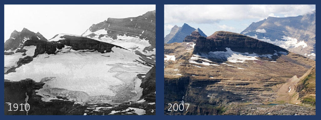
Figure 1. Repeat photography of Boulder Glacier in Glacier National Park, United States, photographed in 1910 and again in 2007 from a closely matched viewpoint. Fixed landmarks in the surrounding mountains help locate the original camera position, allowing visible changes in glacier extent and landscape condition to be compared through time. Historic photograph: E. R. Elrod, Glacier National Park Archives. Repeat photograph: D. B. Fagre and S. A. Pederson, U.S. Geological Survey.
Digital cameras changed this practice. A digital camera could remain at a site and capture images automatically for a long time period. Internet connectivity made it possible to retrieve images remotely. Webcams, originally intended for communication or public viewing, became practical sources of repeated environmental observation.
The shift was significant. Instead of comparing a small number of photographs collected years apart, researchers could begin to build daily or sub-daily records of changing landscapes and vegetation.
In forest research, fixed cameras showed that visible changes in canopy colour could be related to seasonal development. Spring leaf emergence, canopy greenness, autumn colour change, and leaf fall all produced recognisable patterns in image sequences. The camera did not observe plant physiology directly, but it captured visible evidence of changing canopy conditions.
Similar ideas have also been applied beyond vegetation monitoring. Time-lapse cameras can provide frequent observations of rivers without placing sensors directly in the water. A camera installed on a riverbank, bridge, or nearby structure can observe water level, channel width, visible water margins, sediment movement, ice, or flooding. When combined with a staff gauge, survey information, water-level logger, or discharge measurements, image sequences can support the estimation of water stage and, in some cases, river discharge.
Shoreline monitoring offers another useful example. Repeat images from fixed viewpoints can show beach erosion and accretion, storm impacts, changes in vegetation, and the movement of the shoreline through time. Community-based projects such as CoastSnap show that repeat photography can also involve members of the public, provided images are captured from a consistent, documented viewpoint.
The method was simple enough to be widely adopted and structured enough to support quantitative analysis.
The emergence of the PhenoCam network
The PhenoCam Network transformed repeat photography from a useful local technique into a distributed environmental observing system.
PhenoCams are fixed digital cameras that repeatedly observe vegetation, usually from a tower, building, or other elevated viewpoint. They are directed towards a defined part of a forest canopy, grassland, crop field, shrubland, wetland, or other vegetation target. This selected part of the image is commonly called a region of interest, or ROI.
Images are acquired throughout the day, often at regular intervals. Researchers define one or more regions of interest within the image, extract information from the red, green, and blue channels, and create time series that describe visible seasonal change.
The original focus was vegetation phenology: the timing of spring green-up, canopy development, autumn senescence, and the overall duration of the growing season. Over time, the approach has been applied across many ecosystem types and linked with field observations, flux towers, airborne campaigns, and satellite products.
The important achievement of PhenoCam was not simply the use of standardised cameras. It was the development of a shared observation system.
The network combined repeated images with documented installation procedures, stable viewpoints, defined regions of interest, image archiving, quality control, derived data products, and openly accessible datasets. This allowed observations from individual sites to become part of a wider scientific resource. The PhenoCam dataset includes hundreds of sites and thousands of site-years across forests, grasslands, wetlands, agricultural systems, and other vegetation types.
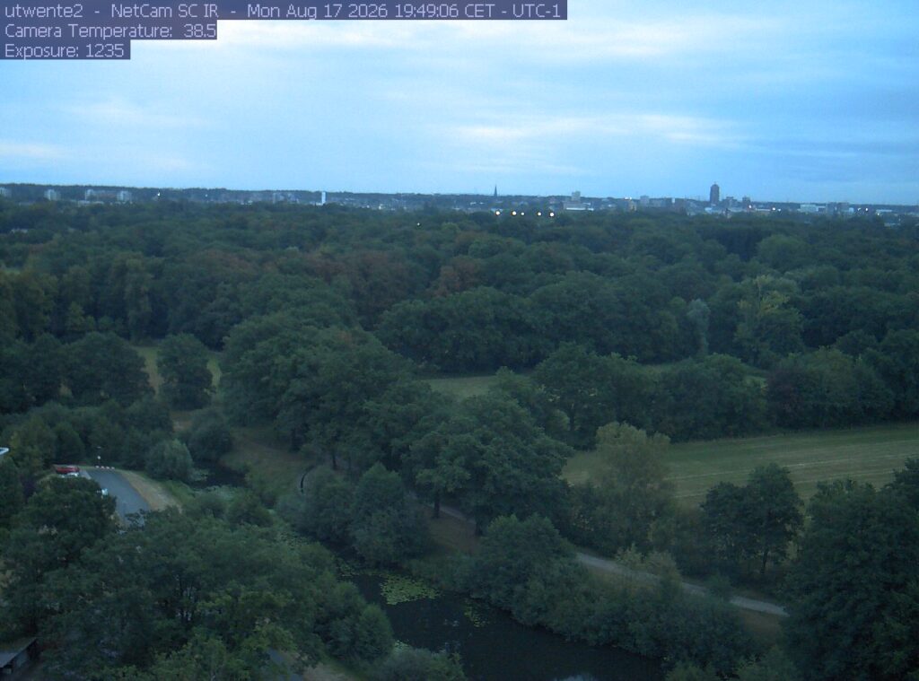
Figure 2. A repeat RGB image from the PhenoCam Twente2 installation on the University of Twente campus in the Netherlands, looking towards Enschede city centre. A fixed camera viewpoint can provide a continuous record of vegetation and environmental change within a defined scene.
What an RGB camera records
An RGB image contains three layers of information: red, green, and blue digital values. Most environmental cameras record these three visible-light channels. Some image formats may also contain an alpha channel, which is used to describe transparency in digital graphics, but this is generally not relevant for field-camera observations or repeat RGB analysis.
The values recorded in an image are shaped by many factors:
- The illumination reaching the target, such as direct sunlight, diffuse cloud light, shade, or reflected light.
- The target itself, meaning the part of the scene intended for observation, such as a crop canopy, grassland, river surface, shoreline, snow patch, or soil surface.
- The reflectance, colour, texture, and structure of leaves, soil, snow, water, or other surfaces.
- The viewing angle, field of view, and background visible in the image.
- The camera lens and sensor response.
- Exposure settings, white balance, image compression, and internal processing.
- Weather conditions, including clouds, fog, rain, haze, shadows, and direct sunlight.
If five different cameras are used to photograph the same landscape, they will probably not produce exactly the same image. Their lenses, sensors, colour processing, exposure settings, and white-balance behaviour will differ. The same camera can also produce visibly different images on sunny, cloudy, clear, hazy, wet, or shadowed days.
An RGB image consists of thousands or millions of individual pixels. Each pixel contains a red, green, and blue value. Combining these values produces the final colour seen in the image.
These colours can sometimes provide useful information about vegetation condition. A green canopy may indicate active vegetation, while yellowing or browning can indicate senescence, drought, nutrient limitation, disturbance, or other forms of change. But this is initially an interpretation based on previous knowledge of the target and the context in which it is observed.
An RGB image is therefore not a direct measurement of chlorophyll, biomass, photosynthesis, soil moisture, or plant stress.
It is an observation of visible light recorded by a particular camera, in a particular location, at a particular time.
This distinction is essential. A visible change in an image may reflect a meaningful environmental change, but the relationship must be established for the target and application under study.
The practical strength of repeat RGB photography is often found in relative change through time. When the same camera observes the same scene consistently, gradual changes in colour and appearance can become interpretable as a time series.
Researchers often calculate simple colour-based metrics from RGB images to summarise these changes. One common example is the green chromatic coordinate, usually referred to as GCC. It expresses the relative strength of the green channel in relation to the red, green, and blue values in an image or region of interest.
These indices can help describe changes in canopy greenness or other visible properties within a defined part of an image. They do not create new information beyond the image itself. Instead, they provide a structured way to summarise a repeated image record.
Any RGB camera can be useful
Repeat RGB photography does not always require a specialised PhenoCam.
A trail camera, consumer webcam, smartphone, digital single-lens reflex camera, Raspberry Pi camera, low-cost IoT camera, or commercial field-camera system can all capture useful repeated observations. The most appropriate system depends on the target, required image quality, power availability, communication options, environmental conditions, and intended duration of the deployment.
A simple trail camera can document crop emergence, grassland development, grazing events, surface wetness, snow cover, vegetation disturbance, or visible changes in a field. A connected RGB camera can transmit images from remote sites. A thermal or near-infrared camera may add other forms of information. Edge processing can reduce transmission requirements by selecting images, detecting scene changes, or performing quality checks locally.
The camera itself does not determine the scientific value of the system. A carefully placed trail camera that records a stable grassland scene for two years may produce a more useful record of seasonal change than a sophisticated camera that is moved frequently, poorly documented, or not maintained.
The key requirements are consistency, context, care, and good documentation. A useful system has a clear target, stable camera position, known acquisition schedule, documented settings, reliable timestamps, and a plan for storing and reviewing images.
Standardisation changes what can be compared
There is an important difference between a repeat-imaging camera and a standardised camera observation system.
A local field camera may be designed for a specific research question. It may use a particular camera model, mounting position, image interval, exposure mode, and processing workflow. This can be entirely appropriate. The goal may be to understand change at one field site, monitor a particular experiment, or provide context for another sensor.
A standardised system has an additional ambition: comparison.
For observations to be compared across sites, seasons, camera types, and research groups, the way images are acquired and processed becomes important. Camera configuration, orientation, field of view, timing, white balance, image resolution, regions of interest, metadata, and quality-control procedures all affect the resulting time series.
PhenoCam provides a useful example. The network distinguishes between camera types and levels of standardisation. Its most standardised installations follow defined protocols and include active collaboration around installation, maintenance, troubleshooting, and data quality. Fixed white-balance settings are particularly important because automatic white balance can introduce changes in RGB values caused by the camera rather than by vegetation.
Standardisation does not mean that every camera must be identical. Complete uniformity is rarely possible. Camera models change, sensors are updated, hardware is replaced, and manufacturing variation remains.
Instead, standardisation means that the observation system is described well enough for its data to be understood and compared. A network can include different camera models and still be scientifically useful if those differences are documented, processing is transparent, and uncertainty is considered.
This is an important direction for future field-camera networks. The goal should not be to exclude low-cost or non-standard systems. It should be to make their observations legible through good documentation, appropriate calibration procedures, and transparent low-level processing workflows.
Repetition matters more than complexity
The strength of repeat RGB photography is not spectral precision alone.
An RGB camera has broad colour channels and limited radiometric control compared with a calibrated spectrometer. It may record compressed JPEG images rather than raw sensor values. Its observations are affected by illumination and camera settings.
Yet repetition can compensate for some of these limitations.
A field camera that observes the same crop canopy every 30 minutes can show when green-up begins, when canopy development accelerates, when flowering changes the appearance of a field, or when senescence begins. A camera overlooking grassland can reveal seasonal development, mowing, grazing, drought effects, or recovery after rain. A camera facing a snow-covered slope can show the timing and spatial pattern of melt.
The value comes from observing the same target often enough to distinguish persistent change from short-term variation.
A camera does not need to observe every property of a system. It needs to provide a stable and interpretable record of the properties it can see.
Beyond vegetation phenology
Repeat RGB photography is most widely associated with vegetation phenology, but its potential extends further.
In agriculture, cameras can record emergence, canopy closure, flowering, senescence, lodging, management events, residue cover, and visible field disturbance. They can provide temporal context for drone flights, crop sampling, soil measurements, and weather data.
In grasslands, repeat images can support monitoring of canopy greenness, seasonal development, mowing, grazing, and recovery after disturbance. Digital repeat photography has been shown to provide high-temporal-resolution information on grassland canopy greenness and phenology.
In soil and surface monitoring, cameras can document wetness, cracking, erosion, surface cover, tillage, and residue dynamics.
In river monitoring, cameras can be positioned safely outside the channel while retaining a view of the water surface and surrounding banks. Repeated images can provide information on water stage, channel width, visible water margins, flooding, sediment movement, and ice. With suitable reference objects, geometric calibration, and validation against conventional measurements, image-based methods can provide useful estimates of water level and, in some settings, discharge.
In inland-water monitoring, cameras can observe water level, ice, floating vegetation, sediment plumes, and changing surface conditions. In snow and cryosphere research, they can track accumulation, melt, and seasonal transitions. In urban environments, they can support observations of vegetation, shading, surface wetness, flooding, and local environmental change.
In each case, images provide visible evidence and temporal context. They may support quantitative interpretation, but only when the connection between image signal and environmental process is properly evaluated.
From simple cameras to shared infrastructure
Repeat RGB photography is now entering a new phase.
Cameras are becoming cheaper, more reliable, and easier to connect. Solar power, low-power communications, local storage, edge processing, automated quality checks, and cloud-based data systems make it increasingly practical to operate cameras in remote or distributed settings.
The technological opportunity is clear. But the main challenge remains methodological. A collection of images is not yet a dataset. A collection of connected cameras is not yet a scientific network. Cameras need persistent identifiers. Images need stable filenames and timestamps. Every site needs metadata, camera configuration records, documented targets, quality-control procedures, and transparent processing methods. Where possible, camera records should be linked to weather data, soil measurements, plant observations, drone imagery, flux measurements, and satellite products.
This is where repeat RGB photography connects directly to the broader idea of proximal sensing.
The earlier articles on this site provide three useful perspectives. Field cameras: the persistent observers of proximal sensing discusses cameras as components of an observation system that provides continuity between field visits and larger-scale observations. Proximal sensing across research fields: one term, many traditions shows how similar principles can be adapted across vegetation, soil, inland water, snow, and urban environments. Proximal sensing: a field between fields places these systems within the wider methodological space between direct measurement and more distant observation.
Repeat RGB photography illustrates all three ideas. The sensors are simple, but the measurements can become valuable when the target is well defined, the observation geometry is stable, the acquisition is repeated, and the resulting data are documented carefully.
A simple instrument with a long memory
RGB repeat photography remains compelling because it is accessible. It can begin with an ordinary camera, a stable mount, and a sensible capture schedule. It can support a focused local research question without requiring a continental network. It can also become part of a larger observatory when images, metadata, workflows, and quality-control practices are shared.
The camera is simple. The observation system around it is not.
That distinction explains why repeat RGB photography has become an important method in proximal sensing. Sustained observation, careful documentation, and shared practice can turn an ordinary camera into a scientific instrument.
Explore further
- Richardson, A. D., Jenkins, J. P., Braswell, B. H., Hollinger, D. Y., Ollinger, S. V., and Smith, M. L. (2007). Use of digital webcam images to track spring green-up in a deciduous broadleaf forest. Oecologia, 152, 323–334. https://doi.org/10.1007/s00442-006-0657-z
- Sonnentag, O., Hufkens, K., Teshera-Sterne, C., Young, A. M., Friedl, M., Braswell, B. H., et al. (2012). Digital repeat photography for phenological research in forest ecosystems. Agricultural and Forest Meteorology, 152, 159–177. https://doi.org/10.1016/j.agrformet.2011.09.009
- Richardson, A. D., Hufkens, K., Milliman, T., Aubrecht, D. M., Furze, M. E., Seyednasrollah, B., et al. (2018). Tracking vegetation phenology across diverse North American biomes using PhenoCam imagery. Scientific Data, 5, 180028. https://doi.org/10.1038/sdata.2018.28
- Hufkens, K., et al. (2025). Tracking vegetation phenology across diverse biomes using Version 3.0 of the PhenoCam Dataset. Earth System Science Data, 17, 6531–6553. https://doi.org/10.5194/essd-17-6531-2025
- Noto, S., et al. (2022). Low-cost stage-camera system for continuous water-level monitoring. Hydrological Sciences Journal, 67(11), 1654–1667.
An example of how low-cost repeat photography can support non-contact water-level monitoring. https://doi.org/10.1080/02626667.2022.2079415
Leave a Reply