Sometimes you only realise that what you do does not fit neatly into a category when you try to explain it to someone else.
I learned this during my MSc studies, when I spent a great deal of time calculating the likely effects of atmospheric attenuation on land-surface temperatures measured with a drone-mounted thermal camera. Under the conditions we were working in, the estimated effect was very small, likely well below the relatively large uncertainty associated with the thermal camera itself. That was a relief. It meant I could stop worrying about correcting the measurements for an effect that was smaller than the uncertainty of the measurement.
But the question stayed with me.
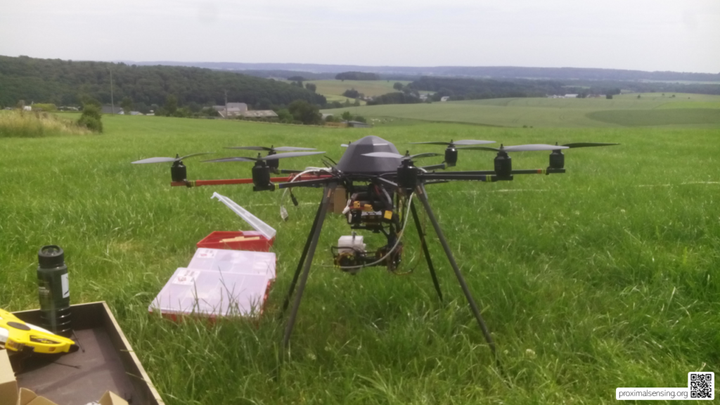
Figure 1. The drone with thermal camera that first raised questions about atmospheric attenuation in close-range thermal observations. Those questions became the starting point for many years of further work and exploration across remote sensing and proximal sensing.
There must be a point at which the atmosphere begins to matter. A sufficiently long measurement path, or particular conditions of temperature, humidity, aerosols, or viewing geometry, can influence the signal received by a sensor. If there is a threshold at which atmospheric effects become important, then there is also a more fundamental question: how far away from the thing we are measuring can a sensor be before we call the measurement remote sensing?
The answer is less straightforward than it first appears.
In vegetation and agricultural science, many familiar instruments are used as reference measurements. Consider sap-flow sensors. Probes are inserted into a tree, one probe is heated, and the movement of heat through the stem is used to estimate sap flow. Installing such a sensor is labour-intensive and invasive. But the atmosphere is not meaningfully part of the measurement path. The sensor is physically coupled to the object being measured.
Other instruments sit somewhere between direct contact and observation from a distance.
A SPAD meter is clipped onto a leaf. A leaf spectrometer may have a measurement head held millimetres or centimetres above a surface. Other instruments use chambers that enclose part of a leaf, creating a small and relatively controlled measurement environment. These devices are clearly not satellites, but they do not all fit comfortably within a simple idea of contact sensing either.
Then there are the more familiar imaging approaches. A camera may observe a crop canopy from a tripod, a tower, a greenhouse rail, a vehicle, or a drone. A thermal sensor may view vegetation from a few metres away or from several tens of metres above it. A terrestrial laser scanner can record detailed structure without touching the target. A radar instrument may be close to the ground but operate through an active interaction between an emitted signal and the surface.
The platform alone does not resolve the question.
How much air needs to be between a sensor and its target before the measurement becomes remote?
A millimetre?
A centimetre?
A metre?
One hundred metres?
And does distance itself provide the most useful answer? Or should the boundary depend on the physical processes that shape the measurement: the sensor, the target, the atmosphere between them, the spatial resolution of the observation, and the degree to which the observer can control the measurement geometry?
This is where proximal sensing becomes useful.
Proximal sensing occupies a scientifically productive space between established categories. It brings together measurements made near a target, often with high spatial detail and considerable control over how the target is observed. It can include non-contact observations, close-range imaging, sensors mounted on field equipment, fixed cameras, and, in some disciplines, sensors in direct contact with or inserted into the material being measured.
The term does not mean exactly the same thing everywhere. In proximal soil sensing, for example, it often includes field-based sensors that measure at or within the soil, whether they are stationary or mounted on a moving platform. In crop sensing and plant phenotyping, it commonly refers to sensors positioned close to plants, including handheld, vehicle-mounted, tower-mounted, and laboratory or field phenotyping systems. In ecosystem research, the related term proximal remote sensing is often used for instruments such as cameras and spectral sensors mounted on towers or within vegetation canopies.
These traditions overlap, but they do not always use the same boundaries.
That lack of a single boundary is not necessarily a weakness. It reflects the fact that sensing systems differ in more than distance. They differ in their physical interaction with the target, their viewing geometry, their sampling scale, their temporal frequency, and the sources of uncertainty that matter most.
One helpful way to think about sensing is as a continuum.
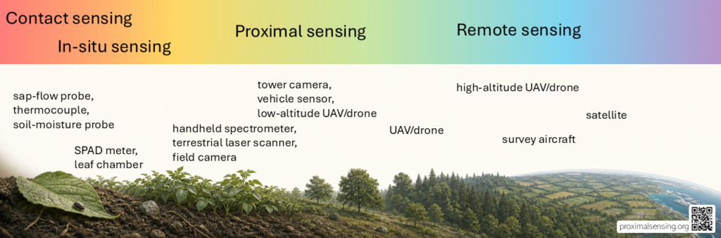
Figure 2. A conceptual continuum from contact and in situ measurement to remote observation. Proximal sensing occupies a broad middle territory in which sensor-target distance, measurement geometry, spatial scale, and the processes affecting the signal all matter.
At one end are contact and in situ sensors. They physically interact with the material being measured. Thermocouples touch a surface. Sap-flow probes enter a tree. Soil-moisture probes are inserted into the soil. These measurements are closely coupled to the target, and the sensor itself is part of the measurement environment.
At the other end are observations commonly described as remote sensing. The sensor and target are separated by a substantial distance, and the signal may be substantially affected by the atmosphere or by other conditions along the measurement path. Satellite observations are the clearest example, but airborne observations can also fall within this category.
With satellite observations, users often have limited influence over the conditions of acquisition. If a scene is cloudy, the measurement may be obstructed or unusable. The observer cannot simply move the sensor, alter the viewing angle, or repeat the measurement a few minutes later. Even when the orbit and acquisition time are known, the practical measurement geometry and environmental conditions are not fully under the user’s control.
Between these ends lies a large and important middle ground.
That is the territory in which proximal sensing is most useful as a concept.
A sensor can be close to its target and still have an atmospheric path between the two. That path may be negligible for one application and important for another. A thermal camera looking at a canopy from a short distance may be affected far more by calibration, emissivity assumptions, changing illumination, mixed pixels, or canopy structure than by atmospheric attenuation. But this should be evaluated rather than assumed. Under different conditions, the atmosphere can become relevant.
The same is true of spatial scale. A drone flying low over a potato crop may produce centimetre-scale observations, but that alone does not determine how the measurement should be classified. A camera mounted on a tower may observe the same patch of vegetation every day from a stable position. A handheld spectrometer may produce a carefully controlled measurement of a single leaf. Each system has a different relationship between sensor, target, environment, and observer.
This is why a simple question such as “Do I need atmospheric correction for drone data?” is often not the most useful starting point.
A better question is: what is the measurement path between the sensor and the target, and which physical processes can influence the signal along that path?
That question directs attention to the things that actually shape data quality. What is the target? How heterogeneous is it? How large is the field of view? Is illumination stable or changing? Is the sensor calibrated? Is the observation repeated in a consistent geometry? Can the target move, or can the sensor position change? How much of the recorded signal comes from the intended target, and how much comes from its surroundings?
Once we start thinking about sensing in these terms, proximal sensing stops looking like an awkward category between two established fields. Instead, it becomes a way to describe a broad class of measurements that share practical and methodological challenges across disciplines.
These challenges appear in soil, vegetation, inland water, snow and cryosphere research, and urban environments. They appear in field IoT systems, fixed cameras, drones, handheld instruments, vehicles, and laboratory-to-field workflows. The platforms differ, but many of the questions are shared.
How close is close enough? Which uncertainties matter? And how can we turn a signal into an observation that is interpretable, repeatable, and useful?
Perhaps that is why proximal sensing is best understood not as a narrow gap between contact sensing and remote sensing, but as a field between fields.
These papers offer complementary perspectives on proximal sensing across soil science, plant phenotyping, and ecosystem monitoring:
- Pierrat, Z. A., Magney, T. S., Richardson, A. D., Runkle, B. R. K., Diehl, J., Yang, X., et al. (2025). Proximal remote sensing: An essential tool for bridging the gap between high-resolution ecosystem monitoring and global ecology. New Phytologist, 246(2), 419–436. https://doi.org/10.1111/nph.20405
- Viscarra Rossel, R. A., Adamchuk, V. I., Sudduth, K. A., McKenzie, N. J., and Lobsey, C. (2011). Proximal soil sensing: An effective approach for soil measurements in space and time. Advances in Agronomy, 113, 237–283. https://doi.org/10.1016/B978-0-12-386473-4.00005-1
- Tao, H., Feng, H., Xu, L., Mistele, B., Schmidhalter, U., and Chen, S., et al. (2022). Proximal and remote sensing in plant phenomics: 20 years of progress, challenges, and perspectives. Plant Communications, 3(6), 100344. https://doi.org/10.1016/j.xplc.2022.100344
Leave a Reply